Showing posts with label Mountains. Show all posts

Saturday, July 11, 2026

In the Beauty of the Lilies

2025 Gray's Lily did not reappear in 2026.


 It's been a hard summer for the lilies on my favorite mountain.
 I always look forward to blooms of Gray's lilies in mid-June and Turks Cap Lilies in early July, but this was as sparse a season as I've seen. The Gray's Lily is found on only a few mile-high summits in the corner of North Carolina, Virginia, and Tennessee.
 For several years, I've been taking a census of Gray's Lilies on Elk Knob. These perennials are already considered rare, and I'm concerned that the population in 2026 seems to be in retreat. I found only four in 2026, compared to 33 flowers in 2025, 18 in 2024, 17 in 2023, and 12 in 2022.
 One patch that produced nine lilies in 2025 showed only one in 2026. Two prolific stalks that produced five and seven flowers did not sprout this year.
 This also was a lean year for flame azalea, which turn the mountaintop orange each June. The Turk's Cap lilies have certainly moved downhill, and we even had one bloom in the parking lot. I counted more than 50 blossoms along the trail, but there were none in the usual thicket past the 1.5-mile marker.
 My census is not scientific, and I generally count flowers visible from the trail. Except for a few patches, I don't bushwhack to find them. I don't want to trample them, and this year the state park put up fences and signs to protect endangered plants.

 On the Sunday after July 4, my church sang The Battle Hymn of the Republic, which I was surprised to learn was still in the Methodist Hymnal. I thought it had been exiled by pacificists, along with Onward Christian Soldiers.
 Our pastor, a former soldier himself, told how he once included that hymn in a worship service in Alabama, and one of the ladies of the church walked out in protest. "I'm not singing a Yankee song," she said.
 Indeed, The Battle Hymn of the Republic echoes John Brown's Body, a favorite tune of Union soldiers. Julia Ward Howe wrote the lyrics in 1861, four weeks after the bombardment of Fort Sumter. It also evokes the University of Georgia fight song, Glory, Glory to the Bulldogs, which might offend my pastor, an Auburn man.

Mine eyes have seen the glory of the coming of the Lord,
He is tramping out the vintage where the grapes of wrath are stored. 
He has loosed the fateful lightning of his terrible swift sword,
His truth is marching on.
 The fourth stanza evokes the Song of Solomon and the Sermon on the Mount: 

In the beauty of the lilies, Christ was born across the sea,
with a glory in his bosom that transfigures you and me. 
As he died to make men holy, let us die to make men free,
while God is marching on.

 The "Father of Botany," Asa Gray, discovered a red lily in 1840 on Roan Mountain, and his students named it for him. A colleague of Charles Darwin, Gray understood evolution as being guided by God's hand.
 In a wonderful coincidence, Gray and Julia Ward Howe, the lyricist for the Battle Hymn, now are pushing up daisies in the same graveyard, Mount Auburn Cemetery near Boston.
 Gray's Lily (lilium grayi), Turk's Cap Lily (lilium superbum), and Michigan Lily (lilium michiganense) bloom in June and July on Elk Knob. ln the spring, we are also blessed with yellow Trout Lilies (erythronium americanum), which Dr. Gray would tell us are not true lilies. 
 Elk Knob and the Roan are among the few places that Gray's lily can be found. They seem to prefer mile-high balds, and Elk Knob is in the process of going bald. 
 
Turk's Cap Lily


Two lilies that bloomed in a new location this year were "harvested"—I'm not sure if they were eaten by deer or picked for a dear. 

This Gray's Lily never bloomed, probably because of drought.

Skeletons of the Beech forest on the summit.
 
  Elk Knob is crowned by a beech forest, and many of the trees have been killed by a blight. As a result, the undergrowth is unusually thick, including a new generation of beech trees. I fear that this is choking out the lilies and the azaleas, which seemed to be retreating away from the summit. If you're looking for a science project, please come study the evolution of Elk Knob and apply Dr. Gray's understanding of theistic evolution. 

Wednesday, March 25, 2026

The Kneverest Hall of Fame


Elk Knob beckons from my bedroom window (I need to call the tree-trimmers).


 I've had my eyes on Elk Knob since we built our mountainside house in Boone in 2005. On Thursday, March 26th, 2026, I celebrated my 300th hike up the mountain.

 
In 2007, I answered a call for volunteers to help build a hiking trail to the summit. My first climb followed a steep old Jeep trail where realtors once tried to sell mile-high views. Thankfully, the lots were never developed, and the state of North Carolina acquired the land in 2003 to become Elk Knob State Park.
 The original superintendent, Larry Trivette, envisioned a walkable trail to the top, and we agreed to build it by hand, rather than scarring the mountainside with a bulldozer or backhoe. I was among the volunteers who came every Saturday to carve out the trail. Each year, we completed about a half mile of trail. On fall Saturdays, I brought a radio and we worked to the tune of Armanti Edwards as hacked stumps, leveraged boulders, and poured gravel on the muddy spots. After quitting time, if I wasn't too sore or exhausted, I trudged up the old jeep road to reward myself with the hundred-mile view.
 We completed the trail on Sept. 4, 2011, which was my 29th ascent. I reached No. 100 in 2019, No. 200 in 2023, and No. 300 in 2026. 
Could I reach 400 this year? Why not, now that I'm retired? Why not do two a day? I know of a Holocaust survivor in Phoenix named Sam Wagman, who climbed Camelback Mountain three times a day, six days a week, for 37 years, setting a world record with 34,000 climbs. His record is safe with me. 

I had the honor of dumping the last load of gravel on the Elk Knob trail in 2011.

 "Groundhog Day" is celebrated at Gobblers Knob, and Elk Knob has become my personal #GroundhogDay. Wake up and do it again. With a few excuses, I've missed only four months for the past 10 years. My streaks reached 48 consecutive months before the park was closed in 2020 because of the COVID pandemic, then another 54 months before we were gutted by Hurricane Helene. Until that seven-week shutdown, I was on pace to tally 70 hikes in my 70th year.
 
Why, you ask? That's what they asked George Mallory in 1924 before his ill-fated climb of Mount Everest. "Because it's there," he declared.
 Why do I come back, month after month? Elk Knob is not Everest, but it's high enough—one of the 52 highest peaks in North Carolina. The view is always nice. Hiking is healthy and seems to keep my diabetes at bay. 
(If you want to impress your cardiologist, send him a summit photo five days after he put stents in your heart.) I like to stay acquainted with the wildflowers. I feel a sense of ownership in the park and trail. I confess to being obsessive. 

The elevation is actually 5,558.
 And I'm over halfway to a Hall of Fame. The International Poly-Baggers Hall of Fame recognizes peak-baggers who have climbed the same mountain 500 times. This is an online club based in Wales. When and if I get there, maybe they'll let me rename the club into something that fits in an obituary. My favorite so far is the "Neverest" Hall of Fame. Or in the case of Elk Knob, we could borrow the silent K and call it Kneverest.
 
Elk Knob is a 4-mile round trip with 1,000 feet of elevation gain from the parking lot. By mountain-climbing standards, it's a humble ascent. My usual round trip takes a little over two hours. Some people can run a marathon faster than that. My fastest climb was 52 minutes at age 57. I've walked over 1,200 miles on "my" trail.
 Do I have the record for Elk Knob climbs? Maybe. There is another man who hikes as often as I do, but he does not keep count. Others have done more on other peaks, like Mount Le Conte. 
 If hikes were stackable, like shoeboxes, my 300 would rise 300,000 feet, which would approach the Kárm
án Line, the brink of outer space, over 10 times higher than Everest and a quarter of the way to the international space station. 

Thursday, July 10, 2025

Before LeConte Lodge was born

The 1923 pioneers: guide Wiley Oakley, Gertrude Schwass, Frank Freels, and Jennie Russ were "like drowned chickens" when they made it back to Gatlinburg. Gertrude's hat had been nibbled by a mouse while she slept, and their hiking boots were ruined by the mud. (Orpheus Schantz photo, Appalachian State University archives)     
 
July 16 marked the 100th birthday of LeConte Lodge. As the co-author of LeConte Lodge / A Centennial History of a Smoky Mountain Landmark, I was invited me to speak at supper July 17 (as I did last August at Myrtle Point to mark the centennial of the 1924 national park commission hike). —Tom Layton

Professor Orpheus Schantz
(Appalachian State University archives)
 On July 11, 1925, the Great Smoky Mountains Conservation Association authorized Paul Adams to establish a camp on Mount Le Conte. He hired some local boys and erected a tent not far from the Basin Spring.
 Five days later came the first guests, as Professor Orpheus Schantz brought a group of tourists and students from Chicago. Schantz paid $32 for his group to stay two nights. Since then, there's always been a human and commercial presence on Mount Le Conte.
 That winter, Adams built a crude cabin, and in 1926 Jack Huff opened the original 32-bed LeConte Lodge cabin. 
 Professor Schantz may have been first at the lodge, but that wasn't his first time atop Mount Le Conte. He climbed the mountain back in 1923, with three friends from Chicago. I recently located a scrapbook that details that adventure—long before the lodge was born.
 Schantz was a professor at the University of Chicago, president of the Illinois Audubon Society and a member of the National Geographic Society. His scrapbook reveals a playful and poetic spirit. He first visited the Smokies in 1918 and was a 49-year-old widower on his fifth trip in June 1923.
 He hired guide Wiley Oakley, "the Roamin' Man of the Smokies, " and enticed his entourage (Gertrude Schwass, Fred Freels, and bank secretary Jennie Russ) to hike up Mount Le Conte. The trail-less mountaintop was owned by Champion Fibre Company, which intended to harvest the balsam forests, churn the timber into pulp, and sell trainloads of newsprint to papers across the country.
 A logger named Andy Huff had opened a boarding house in Gatlinburg, which became the Mountain View Hotel. He sent a few of his loggers up Le Conte Creek (then known as Mill Creek) to "swamp out" a rough trail. When Knoxville newspaper columnist Carson Brewer investigated the history of Le Conte cabins in 1962, Ranger John Morrell, Paul Adams, and Harvey Broome told him  that this lean-to was the first habitable structure on the mountaintop. It became the base camp for the federal national park commission that Adams hosted in 1924. And the year before that, Schantz' soggy hikers spent a Saturday night there. 
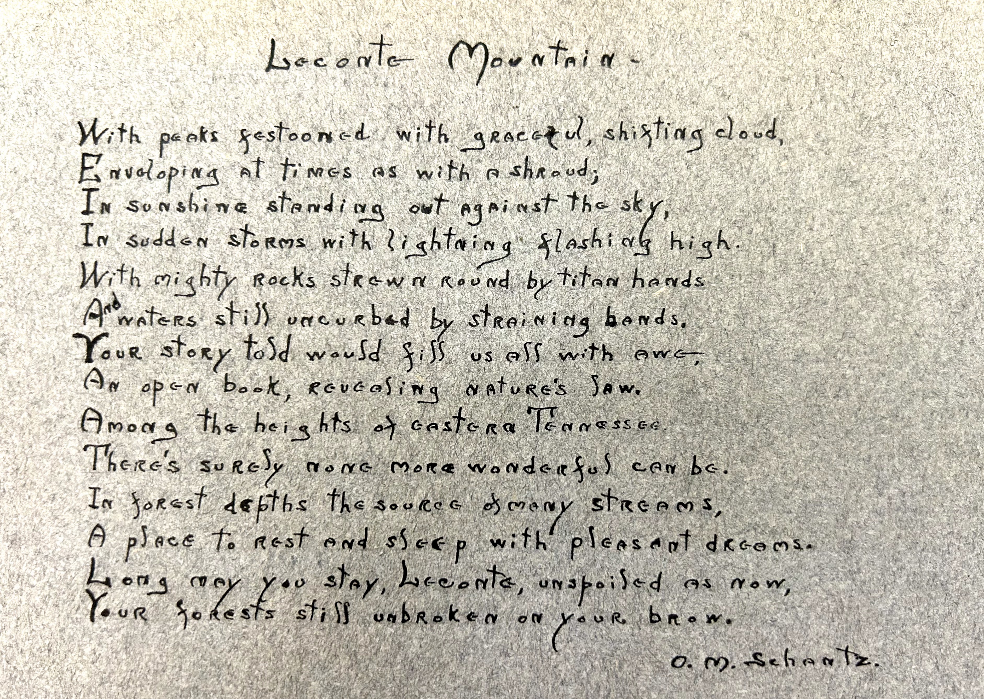
 Our book includes a shadowy photo of the lean-to, but it is better illustrated on this poem by Professor Schantz. 
Click to enlarge. (Appalachian State University archives)

 Jennie and Gertrude composed lengthy reports that are enclosed in the Professor's scrapbook. They described the 600-mile journey from Chicago, starting June 16, including 30 miles from Knoxville to Sevierville on a rail-bus called an interurban and 15 miles to Gatlinburg in Andy Huff's Ford. As they waited for a break in the weather, they explored the valleys and delighted in the mountaineers' accent, the fireflies and the luxuriant rhododendron. One day they were amused to find a swimming hole with a sign that said: "When bathing here, you must wear a bathing suit or other clothes, if you have none you must stay out." On one trip to Elkmont, their driver was 19-year-old Jack Huff.
 "The trip up LeConte* was postponed from day to day on account of weather conditions," Jennie wrote, "but one morning we decided that as our time was growing shorter, we had better risk going or we might miss it entirely."
*The Professor spelled "LeConte" without a space. That's also how Huff painted it on the original lodge sign, which explains why LeConte Lodge is spelled differently than Mount Le Conte.
 
 Here's how Gertrude headlined the hike in her journal:

THE NEVER-TO-BE-FORGOTTEN
--June 23rd and 24th, '23.
The Hiking Shoes can tell a story-
 
 "The Jolly Four," as Professor Schantz called them, trudged through the rain up the road to Cherokee Orchard, took shelter in a deserted cabin, and then proceeded up Mill Creek (now the Rainbow Falls route). At the waterfall, they climbed a makeshift ladder to the top of the cliff, and pressed upwards past suppertime. "The twilight was deepening," Jennie wrote, "when we saw the black outline of the lean-to just ahead. The guide soon had a roaring fire made and our supper cooked." The ladies were too tired to eat much.
 "We laid on the sweet-smelling balsam bed with the stars very near and bright," Jennie wrote. 
 Gertrude wrapped herself in a blanket. At one point she reached for her flashlight and was surprised to feel a bristly patch of bear fur that Wiley had put there as a prank. A mouse scurried under the bed frames, and during the night it chewed up Gertrude's hat.
 In the morning, they freshened up at the Basin Spring, ate breakfast, and climbed up to Cliff Top. "The government had put a tablet in a rock at the summit indicating the height as 6,685 feet*," Jennie wrote. They registered their names in a notebook—perhaps the same one that C.L. Baum had placed in a Prince Albert can in 1922. 
* If this elevation had been correct, Cliff Top would have inched ahead of Mount Mitchell, 6,684, as the highest point in the Appalachians. And High Top is even higher than Cliff Top.

 Rainclouds spoiled the sunrise view and then poured torrents as the Jolly Four climbed down the slippery path. When they got down to Cherokee Orchard, they found that someone had sent two horses for the ladies to ride the final miles into town.
 "When we arrived at the hotel, all of the guest were on the porch to greet us," Jennie wrote. "They were mildly astonished as the two girls of our party ate their supper as usual. Their astonishment increased when they appeared the next morning for breakfast. It had taken the last young woman who climbed Le Conte three days to recuperate."
 The ladies' hiking boots were casualties. "Our hiking shoes came to a sorry end, soaked and marred, we were unable to wear them again while in Gatlinburg," Gertrude wrote. 
 "Le Conte shall never be forgotten by the 'Jolly Four,'" the Professor said. "A tale we can be proud to tell our grandchildren."
 Presumably, Wiley told Jennie and Gertrude that women had made this climb before. Back in 1916, he had guided Maisy Graves and Mollie Kimball up the old Bear Pen Hollow Trail. They also got soaked and, lacking a cabin, slept under a ledge.

Wiley Oakley's children at his cabin on the slopes of Mount Le Conte. (Appalachian State University archives)

"Long may you stay, Leconte, unspoiled as now" —Professor Schantz 

Thursday, June 26, 2025

Found! The Holy Grail of LeConte's Centennial

Schantz (fourth from left) with stylish University of Chicago students on a 1927 ecology field trip to the Great Smoky Mountains (University of Chicago archives)

 Orpheus Schantz was one of the original Smoky Mountain tourists and is remembered as the first paying guest at LeConte Lodge. His 1951 obituary in The New York Times described him as "one of the group instrumental in establishing the Old Smoky Mountain National Park."

New York Times proofreaders didn't catch 'Old Smoky' instead of 'Great Smoky'. That year, 'On Top of Old Smoky' was a popular song by the Weavers.


 Schantz' visit to Paul Adams mountaintop tent July 16-17, 1925, marks the birthday of LeConte Lodge. As Mike Hembree and I researched our book, LeConte Lodge, we knew that Schantz's pioneer experiences would be vital to the story. We tried to track down his journals, letters, or photographs, and even considered a wild-goose-chase road trip to the University of Chicago, where he taught.
 We had no luck before the book was published in January. Then recently, I stumbled across one of Schantz's scrapbooks right here where I live in Boone, North Carolina—in the library at Appalachian State University. I'd spent days in the special collections there, dredging up LeConte material and helping Mike research the university's NASCAR collection for his book, Petty vs. Pearson.
 Meanwhile, the Holy Grail of LeConte Lodge (acquired by App State in 2021) was keeping Schantz's secrets in an adjacent room.
Knoxville Journal, Nov. 1, 1925
 Schantz was raised on the Canadian shores of Lake Huron, became became a professor at the University of Chicago,
married Carrie Flagler in 1889, raised two children, and was widowed in 1922.
 He made his first pilgrimage to the Smokies in 1918, when Andy Huff's Mountain View Hotel had only four rooms and the trip from Sevierville to Gatlinburg was by horse and buggy.  
 As a leader in the Audubon Society and a contributor to National Geographic magazine, Schantz led the 1932 Smoky Mountain Faunal Survey which identified 37 mammals in the future national park, including a rock vole that is found nowhere else in the world. "This region has been unknown zoologically," said E.V. Komarek of the Chicago Academy of Sciences. 
 Carlos Campbell, author of "Birth of a National Park in the Great Smoky Mountains," praised his influence: "Mr. Schantz has done more to boost the Smoky Mountain National Park project than any other person who is not directly connected with the movement."
 Our book documents a 1924 meeting between Schantz and Adams, who was commissioned in 1925 by the Great Smoky Mountains Conservation Association to establish the first public camp atop Mount Le Conte. They attended a scientific convention in Nashville, where Adams gave a presentation from his August 1924 climb with the Southern Appalachian National Park Commission: "Trips with the National Park Commission and Bird Check Lists Obtained." 
 The fellow bird-watchers had much more in common than we previously knew, since Schantz had camped on Le Conte in 1923. That was when Wiley Oakley guided Schantz, Frank Freels, Gertrude Schwass, and Jennie Russ up Mount Le Conte. Schantz, 49, wrote:

This is the tale of the jolly four
who spent the night on a balsam floor
on top of Leconte in Tennessee
above the clouds 'neath a balsam tree.

Hikers at the lean-to used by the 1924 federal national park commission. It's possible that this is where Schantz camped in 1923. (Dutch Roth archives)

 When I first read Schantz' description of the balsam bedding, it sounded so much like Adams' 1925 tent that I wondered if Schantz might have gotten the year wrong in his scrapbook. But the fact that he doesn't mention Adams indicates that these are two separate trips.
 On July 16, 1925, Schantz brought a larger group up to Adams' brand-new tent camp, paying $36 for 12 guests and two guides (Oakley and Will Ramsey) to spend two nights on the mountaintop.
 Schantz led dozens of excursions to the Smokies and climbed Le Conte at least 10 times. His son set up a travel agency that advertised "Springtime in the Smokies" to nature-loving friends from Chicago, and he often had enough guests to fill a Pullman passenger car for the two-day trip from Chicago to Knoxville.

Photographer Jim Thompson visited Paul Adams' camp on July 17, 1925. It appears that Professor Orpheus Schantz' group is seated in front of the tent. Adams is holding the ax. Uncle Ike Carter (standing at left in front of the tent) was once recognized as Le Conte's oldest climber; Dutch Roth is fourth to the right of Carter; and the men between them may be guides Wiley Oakley and Will Ramsey. The boys in the rear are probably some of Adams' workers (Levater Whaley, Earnest Ogle, and brothers Rellie and Bruce Maples). The structure at top right is a canvas lean-to where Adams lived. (Jim Thompson archives)

Archives at the University of Chicago include this photo of the original LeConte Lodge,
built by Jack Huff in 1926. This was filed as "Cabin in the Great Smoky Mountains," so it was easily overlooked.

 LeConte Lodge's centennial celebration will be low-key. The national park has not announced any plans for ceremonies at the lodge. I am planning to visit on July 17 (which will correspond to the second night of Schantz' 1925 trip), and we'll celebrate with guests and crew. 

Orpheus Moyer Schantz signed the lodge logbook after his 10th climb in 1938.
Notice how many of the early guests were from the Upper Midwest.

Thursday, May 16, 2024

Elk Knob in Bloom

Last Gray's lily of the season (6/26/2024)


Same plant (2023)

 Elk Knob is a mile-high mountain in Watauga County, North Carolina, just 15 miles from my doorstep in Boone. It's been a state park since 2003, and for several years in my 50s I volunteered to help build the hiking trail to the summit. I try to hike at least once a month, often after work on summer evenings.
 The masthead of this blog shows the sun rising over Elk Knob, with a photo taken from adjacent Snake Mountain.  
 In 2024, my 70th year, my goal was to "hike my age"—70 trips to the summit. I was on pace to make it until Hurricane Helene struck and closed the state park for six weeks. In December, I hit 65, but the mountain and I were under the weather for the rest of my 70th year.
 This goal put me on the trail several times a week, so to keep the trips from getting tedious, I given them a purpose—this wildflower journal. I'm no authority on wildflowers, just learning on the way.
 The big show on Elk Knob is in June. In 2024, flame azalea bloomed June 6-20 and Gray's lilies June 8-26. These quickly dried up, and by the end of the month, pollinators were grazing on the drooping leftovers.
 Turk's Cap lilies were in bloom through July, along with coneflowers and turtleheads and the relentless purple Angelica. 
 Elk Knob is one of the few places in the world where you can see Gray's lily. They are named for Harvard botanist Asa Gray, who happened to be on Roan Mountain when they bloomed in 1840. 
 My experience is that if you're a day early or a day late, you may miss them. These perennials are also ephemerals. 
 For the past three years, I've taken an informal census of the Gray's lilies on Elk Knob. This year, I found 17 plants and 18 blossoms (plus more than a dozen lilies that never blossomed). Last year, 10 plants and 17 blossoms. In 2022, I did not count plants but found 12 blossoms. These are just plants I find along the trail, plus a couple of off-trail locations that I know. Certainly, there are many more elsewhere on the mountain, but this trailside sample gives me an indication that the population on Elk Knob is stable.
 As perennials, Gray's lilies can be found in the same place year after year. Also, wildlife scatter the seed to new locations. We evidently lost one lily, which had six blossoms last year but did not reappear in 2024. It was in the midst of the blighted beech forest, so it might have been crushed by a falling tree or nibbled by a deer. 
 Almost all these lilies were above 5,000 feet in elevation. There is one outlier at 4,600 feet, but it is too close to the trail and lost its bud to a broken stem for the second year in a row.


June 2024 was unusually cool and dry, though we were in the clouds on 6/17.

Seed capsule from the above flower (7/23/2024, later mowed down by trail workers)

Monday, September 23, 2019

Hiking the rooftops of the Carolinas

My long-awaited arrival at the summit of Mount Guyot (Photo by Peter Barr)
 Ten years ago, I had never heard of a county highpoint. I had climbed a few mountains that were the highest in their counties, but I didn't appreciate that distinction until I started registering my mountain climbs into an online database called Peakbagger.com. Then to my surprise, Peakbagger started to list me on computer-generated rankings of "county highpointers."
 Before 2009, nobody had completed all the county highpoints of North Carolina nor South Carolina. That piqued my competitive instincts, so in 2010 I began seriously pursuing the county highpoints of my home states. It took me over nine years to reach them all. 
 In 2014, I was able to finish South Carolina's 46 counties along with Charlie Zerphey, a fellow highpointer from Pennsylvania. By then, I had had climbed to the top of 33 of North Carolina's 100 counties, and Charlie and I realized we had a chance to become the first hikers to complete all 146 county highpoints in both Carolinas.
Green counties indicate a completed state.
Yellow marks my other county highpoints.
Pink indicates counties on my wish list.

Dark green is my home county, Watauga.
 The most challenging one, I knew, would be Haywood County, where Mount Guyot is one of the most remote peaks in the Southeast. In 2014, when Charlie was 84, he surpassed me when he climbed Guyot with the Highpointers Club. 
 In 2017, Charlie and I slogged to an island in the Great Dismal Swamp that enabled him to claim Pasquotank County and complete the 100 county highpoints of North Carolina. That left me with two county highpoints to climb—Guyot plus an obscure ridge on the Cherokee County line that I reached in 2018 for #99.
 Mount Guyot is named for a 19th-century Princeton professor who was the first to survey many of our Southern mountains. Arnold Guyot was Swiss, so pronounce it GHEE-oh. Guyot stands 6,621 feet above sea level and about 4,400 feet above the parking lot at Cosby Campground in the Great Smoky Mountains National Park. 
 A Charlotte attorney named Henry Pharr joined me Sept. 20 to climb Guyot. This would be my final North Carolina county highpoint and Henry's 99th. His 100th will be a sand dune on Ocracoke Island, which is not accessible right now because of damage from Hurricane Dorian.
 The 18-mile roundtrip would be the longest hike of my life. The trail doesn't even go all the way to the top of the mountain—the last half-mile is a bushwhack through a dense balsam forest that smells like Christmas trees. 
I was honored that Peter Barr hiked with me.
 Henry and I started up the Snake Den Trail at dawn and hoped to get to the summit by 1 p.m., but I was slow, and it was 4 o'clock before we made it to the top. Along the way, we were joined by Peter Barr from Skyland and Zachary Robbins from Carrboro. Peter first climbed Mount Guyot when he through-hiked the Appalachian Trail in 2000. In 2015, he became the second hiker to complete the North Carolina county highpoints. I am the fourth, also joining state park ranger Brian Bockhahn in 2009 and Charlie Zerphey in 2017. Henry will become the fifth, once Ocracoke reopens.
 We celebrated my landmark with some photos. I brought a North Carolina flag, and Peter led a recitation of the North Carolina state toast, just as one of his friends had done on his completion day. My favorite line says: "Where the weak grow strong and the strong grow great, here's to 'Down Home,' the Old North State."
 Because I was so slow up the hill, we realized we would have to finish in the dark. Under the glow of our headlamps, Peter spotted a couple of snakes on the way down the Snake Den Trail, but they didn't bother us. Henry and I finished about 10 p.m., 15 hours after we started walking.
With Peter Barr and Henry Pharr on the Snake Den Trail, approaching the Appalachian Trail (photo by Zach Robbins)
 If you are interested in pursuing the county highpoints of North Carolina, here is a list that includes my trip reports. (You may have to create a Peakbagger account to read the trip reports.)
 To complete the list, you will visit four national parks, nine state parks, three national forests, three cemeteries, Fort Bragg, an abandoned prison, 11 communication towers, and three water towers. More than half of the highpoints are on private land. If you aspire to be a county highpointer, you'll need to get comfortable approaching strangers and asking them to restrain their dogs while you explore their backyards. 
 In many of the eastern counties (and at least one place in the mountains) you have to visit multiple sites to be sure you have reached the highest ground. One of the most maddening was Edgecombe County, where the USGS topographical maps identified over 30 locations around the town of Rocky Mount that might be the highpoint. I used more modern and precise GPS maps to eliminate two-thirds of those.
 On the other hand, you get double credit when you climb some peaks that are on the county borders. Grandfather Mountain's Calloway Peak is the highest point in Watauga and Caldwell counties, and Standing Indian is highest in Macon and Clay counties. 
 In case you are wondering, the lowest of North Carolina's county highpoints is a pine plantation in Tyrrell County that is only 17 feet above Albemarle Sound. 
 Peter asked me, "Now that you've completed North Carolina, what's next?" Having finished the state where I was born and the state where I now live, I don't have any desire to try to complete any others. I have 268 county highpoints nationally, and I'd like to get to 315, which would represent 10 percent of the nation. The ones marked pink on the map above are among the counties on my wish list. 
 Next year, I may take on another Peakbagger category, peaks with 2,000 feet of prominence. I've climbed all 11 of those in North Carolina, and I need two more in Tennessee (Big Frog Mountain and English Mountain) and one in Virginia (Elliott Knob) to complete the Southeastern "P2Ks." Mercifully, those hikes are just 8 to 12 miles.

Here's where you can find the county high-points of North Carolina:

National Parks
  • Blue Ridge Parkway: Jackson (Richland Balsam), Transylvania (Chestnut Bald), McDowell (Blue Ridge Pinnacle), Henderson (Little Pisgah), Wilkes (Thompkins Knob).
  • Great Smoky Mountains National Park: Swain (Clingman's Dome), Haywood (Mount Guyot)
  • Wright Brothers National Monument: Dare (Kill Devil Hill)
  • Cape Hatteras National Seashore: Hyde
National Forests
  • Pisgah National Forest: Mitchell (Roan High Knob), Buncombe (Potato Knob), Avery (Grassy Ridge Bald).
  • Nantahala National Forest: Graham (Huckleberry Knob), Cherokee (County Corner).
  • Uwharrie National Forest: Montgomery (Dark Mountain).
Other Federal land 
  • Great Dismal Swamp National Wildlife Refuge: Pasquotank
  • Federal Aviation Administration: Rutherford (Sugarloaf Mountain)
  • Fort Bragg: Cumberland
State Parks
  • Grandfather Mountain State Park: Watauga (Calloway Peak), Caldwell (Calloway Peak)
  • Mount Mitchell State Park: Yancey (Mount Mitchell)
  • Elk Knob State Park: Ashe (The Peak)
  • Hanging Rock State Park: Stokes (Moores Knob)
  • Crowders Mountain State Park: Gaston (The Pinnacle of Kings Mountain)
  • Morrow Mountain State Park: Stanly (Morrow Mountain)
  • Occoneechee State Natural Area: Orange (Occoneechee Mountain)
  • Great Dismal Swamp State Park: Camden
  • Jockeys Ridge State Park: Secondary location in Dare County (Jockey's Ridge)
Other state facilities
  • Hoke Correctional Instititution: Hoke
Nature Conservancy
  • Secondary location in Dare County (Nags Head Woods)

Communications Towers
  • Alleghany (Catherine Knob)
  • Surry (Fisher Peak)
  • Polk (Tryon Peak)
  • Cleveland (Benn Knob)
  • Iredell (Fox Mountain)
  • Randolph (Shepherd Mountain)
  • Rowan (Youngs Mountain)
  • Rockingham
  • Alamance (Cane Creek Mountain)
  • Chatham
  • Harnett (Big Ridge)

Water towers
  • Person (Roxboro Hill)
  • Secondary locations in Harnett, Moore
Cemeteries
  • Richmond (Parsons Cemetery)
  • Columbus (Meadow Cemetery)
  • Secondary location in Tyrrell (West Cemetery)
Private land (listed highest to lowest): Madison (Sandymush Bald), Burke (Long Arm Mountain), Alexander (Hickory Knob), Catawba (Baker Mountain), Yadkin (Click benchmark), Lincoln (Buffalo Knob), Davidson (High Rock Mountain), Forsyth, Rockingham secondary location, Davie, Guilford, Alamance (Cane Creek Mountains), Cabarrus, Mecklenburg, Caswell (Stony Creek Mountain), Union, Chatham, Durham (Red Mountain), Granville, Anson (Gordon Mountain), Lee, Wake, Scotland, Warren, Halifax, Northampton, Johnston, Nash, Wilson, Robeson, Sampson, Wayne, Bladen, Duplin, Lenoir, Edgecombe, Greene, Pitt, Jones, Pender, Onslow, Bertie, Hertford, Martin, Gates, Brunswick, Currituck, Beaufort, Craven, Chowan, Perquimans, Pamlico, Washington, Carteret, Tyrrell.

Friday, October 20, 2017

Orval and Buddy: Inseparable to the end

Orval's driveway has this view of Balsam Gap
     Orval Banks and his dog Buddy lived for many years in a cabin atop Chambers Mountain, where Orval manned the fire tower for the state of North Carolina, while Buddy specialized in search-and-rescue missions. I met them in June when I hiked up their steep two-mile-long driveway.
     Orval knew his days on the mountaintop were running short. Cancer had sapped his strength, and the state had decided to close the tower. His son over in Hendersonville was preparing a place for them to live. When I visited, Orval was working on a crate for Buddy to ride down in the back of his pickup truck. It wouldn't be long until they had to leave.
     Orval welcomed me to climb the rickety lookout tower and was sorry he was no longer strong enough to go up there. From his front porch, he fondly pointed out the mile-high mountains that encircled us: the Pisgahs, Balsams, the Lyn Lowry cross, the Great Smokies, Crabtree Bald, the Roans, Mount Mitchell, and others; as well as the landmarks at our feet: Maggie Valley, Waynesville, Lake Junaluska, and Asheville.
     The photo I've posted here is the view from his driveway looking southwest through Balsam Gap toward Georgia. I'm sorry I don't have a picture of the three of us, but I'm not much for selfies, I doubt that Orval would have wanted to pose, and Buddy didn't want me to get too close.

     One of the commands Orval taught Buddy was "show me," and the last thing Buddy did was show Orval the way out of this world. Orval was already on his deathbed on Tuesday when Buddy suddenly became sick. The family took him to the vet, but there was nothing they could do, and at 8 o'clock Tuesday night, Buddy went to sleep for the last time. Orval’s grandson lovingly told Buddy that when he got to heaven, "Stay!" and wait for Orval.
     Buddy didn't have to wait for long. Just two hours later, Orval followed him. They had an amazing life together, and they were inseparable to the end.

     The family sent out a message saying: 
     It was meant to be, Orval followed Buddy around for years. Only fitting that he follows him now. I truly believe that neither one of them wanted to leave without the other. Buddy will also be cremated and his ashes will be spread with Orval's.
     I believe that Orval's Heaven will be endless mountain ridges and valleys. And that he will spend his time crossing each of them, with a pack of dogs in front of him and Buddy leading the way. Orval will be able to breathe again and his body will work again. And all along the way he will find the people he has been searching for, along with friends and family, who have gone before and will follow in the future. And Dad's face will be lit with God's light as he chases the setting sun.
     And for any of you who have been on searches with my Dad and followed him through the woods, there is bound to be occasionally one of the gnarliest briar thickets and Dad will go straight through the middle of it.
     For more about Orval Banks and his gift for communicating with dogs, check out this 2011 story in the Smoky Mountain News.

Tuesday, March 7, 2017

Riddler on the roof: When did N.C. stand tallest?

When Frenchman Andre Michaux stood here in 1794 and declared Grandfather Mountain "the highest mountain of all North America," he overlooked the obvious: The blue ridge on the distant horizon to the right is Mount Mitchell, which was actually the highest peak in the United States for 56 years.
     Jeopardy! champion Ken Jennings writes a blog called Maphead where he posed this question: Before Alaska became a state, where was America's highest mountain?
     It's really more of a riddle than a question. Because for most of our nation's history, no one was sure.

     The answer is California, which owned America's rooftop from the day it became the 31st state in 1850 until 1959 when Alaska became the 49th. Yet Jennings points out that well into the 20th century, atlases mistakenly listed Washington's Mount Ranier as the nation's highest mountain.
     In fact, California was 75 years old before surveyors verified that Mount Whitney was the highest point in the Lower 48. (Even then, there may have been a 10-foot error because the engineer was in such a hurry to get home to his fiancé.) 
     Early topographic maps that used 100-foot contours show a virtual three-state tie among California's Whitney (14,495 feet above sea level in the 1925 survey), Colorado's Mount Elbert (14,431), and Washington's Rainier (14,408). All three have inched up in the latest satellite surveys: Whitney 14,505, Elbert 14,433, and Rainier 14,410.
     Before California, which state stood tallest? Texas had the highest peak in the nation* for five years after it became the 28th state in 1845, though I doubt that anyone knew it. (*I'm not counting the Louisiana Territory, which included Mount Elbert.)
     And before that? The whole country assumed New Hampshire's Mount Washington was highest until this news broke Nov. 3, 1835 in the Raleigh Register and North Carolina Gazette (back in the days before headlines were invented):

     The editor's note (above right) promoted a lengthy front-page article written by Dr. Elisha Mitchell, a professor of geology at the University of North Carolina. (If this link asks you to subscribe to newspapers.com, email me and I will send you a copy.)
     Dr. Mitchell surveyed several mountains in western North Carolina before concluding than an unnamed peak in the Black Mountains was the highest. He measured it at 6,476 feet above sea level, which underestimated Mount Mitchell's actual height of 6,684. Still, that surpassed Mount Washington, which then was believed to be 6,234 feet and is now listed at 6,288. 
     Dr. Mitchell's barometric measurements were generally shorter than the summit elevations we know today. He measured Grandfather Mountain at 5,556 feet (it is now known to be 5,946), the Roan at 6,039 (Roan High Knob is 6,285 and Roan High Bluff 6,267), and Table Rock at 3,421 (rather than 3,920).
Following Dr. Mitchell's footsteps
     He came closer on Yeates Knob (5,895 then, 5,920 now), which is important because Yeates is one of the viewpoints he used to triangulate Mount Mitchell and other peaks in the Black Mountains. (Yeates is now known unfortunately as Big Butt.)
     Dr. Mitchell was aware of other high mountains further west in North Carolina, including the Great Smoky Mountains (where Clingman's Dome rises to 6,643 feet, just 41 less than Mount Mitchell) and the Great Balsams (where Richland Balsam reaches 6,411 and the Blue Ridge Parkway crests at 6,047). His newspaper article said that the Unikee Mountains (the Cherokee name he used for the Smokies) "appear to the eye to be lower than the Black."
     Grandfather, on the other hand, appears to the eye to be even higher than it actually is, because of the way it towers almost a mile above the North Carolina Piedmont. When French botanist Andre Michaux climbed Grandfather on August 30, 1794, he broke into song and wrote exuberantly in his journal, "Reached the summit of the highest mountain of all North America, and, with my companion and guide, sang the Marseillaise and shouted, 'Long live America and the Republic of France! Long live liberty!'"
     From that hyperbole, we can assume the skies were relatively clear and Michaux had a view to the horizon. If so, he overlooked the obvious: Just 36 miles to the southwest, Mount Mitchell stood over 700 feet higher.
Lying here "in the hope of a blessed resurrection,"
Dr. Mitchell has a head start on Heaven.
     Through his 1835 trip and subsequent research, Dr. Mitchell was the first to prove conclusively that North Carolina had the highest ground in the 24 states that existed at the time. This had been the case since we became the 12th state back in 1789. 
     In 1857 (when there were 31 states, including California), Dr. Mitchell returned to the Black Mountains to verify his measurements and settle a dispute with one of his former students, Thomas Clingman, who insisted that his professor had not reached North Carolina's highest peak.
     On June 27, 1857, hiking after dark on the way down the west side of the Blacks, the 63-year-old professor slipped over a small waterfall and fell to his death. The following year, Dr. Mitchell's body was laid to rest on top of North Carolina's highest mountain, and in 1882 the peak that had been known as Black Dome was renamed in his memory as Mount Mitchell.